 eAtlas Data Catalogue
School of Earth and Environmental Sciences, James Cook University (JCU)
Type of resources
Topics
Keywords
Contact for the resource
Provided by
Years
Formats
Representation types
status
-
Sharks play an important role in marine ecosystems but are facing increasing pressure from fishing and other anthropogenic factors. Along the Queensland coast inshore waters play an important role as nursery areas for sharks. However, the same inshore waters are also most prone to fisheries exploitation and effects of freshwater discharge from coastal streams and rivers. This project will examine the importance of different types of inshore habitat (protected bay vs. open coastline) and marine park zoning (open and closed to fishing), and how environmental factors such as freshwater discharge from rivers effect how these nursery areas function. The project has two broad objectives: A. Investigate the spatial and temporal changes in the biodiversity and abundance of sharks in inshore nursery areas along the central GBR coast. B. Determine the effect of environmental drivers on inshore shark biodiversity along the central GBR coast. Results from the project will be used to improve the information available to fisheries and marine park managers on the relative importance of inshore habitats, the role of areas closed to fishing, and the sustainability of inshore shark populations.
-
The project will determine the status of threatened marine (green, hawksbill and flatback) turtles and dugongs in the Torres Strait and threats to these populations. It also will investigate links between different populations of dugongs and turtles in terms of movement and habitat use. They will also assess the abundance of dugongs in the Torres Strait using aerial surveys. Working in conjunction with the Torres Strait Regional Authorities (TSRA) Land and Sea Unit and the TSRA Community Ranger program this project will: 1. Determine the status of green turtles in Torres Strait (sex ratios, patterns of juvenile recruitment, nesting success and hatchling production) using seasonal surveys of green turtle foraging and nesting sites. Foraging sites will vary to cover as many different habitats as possible (e.g. one per year). Nesting sites will include Maizub Kaur (Bramble Cay) and Dowar Island (Mer Group) 2. Determine the status of hawksbill and flatback turtles in Torres Strait by conducting Iama community and Mabuiag Community seasonal surveys and trial remote camera deployments at Sassie Island and Malu Kiai (Deliverance Island) to quantify nesting events, which are suspected to be declining, and predation levels, which are speculated to be high. Data will then be used in combination with survey data collected by QDERM (Col Limpus) since 1992, and other life history and mortality data to determine a robust account of population status. 3. Investigate population connectivity of dugong and green turtles using satellite tracking of dugongs caught in the northern section of Torres Strait (i.e. around Biogu), analysis of previous tracking data (from QDERM, CRC TS, MTSRF and AMMC) of turtles and dugongs and collection of skin samples from dugongs and green turtles to strengthen the genetic understanding. 4. Undertake dugong and turtle aerial surveys in March 2011 and November 2013 of western Torres Strait, including the Dugong Sanctuary and the area west of Orman Reef in association with a parallel survey of the northern GBR. 5. Analyse historical data to examine patterns of turtle abundance in key areas such as western Torres Strait and the Dugong Sanctuary.
-
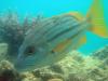
This data set contains life history data from 46 species of coral reef fish from four families (see list below). The data and samples on which these analyses are based were collected as part of the Effects of Line Fishing Project and the East Torres Strait Coral Reef Fishery Project. Species included in this data set include: Labridae: Cheilinus undulatus, Choerodon cyanodus, C. fasciatus, C. schoenleinii, C. venustus Lethrinidae: Lethrinus atkinsoni, L. lentjan, L. nebulosus, L. olivaceus Lutjanidae: Aprion virescens, Lutjanus adetii, L. carponotatus, L. fulviflamma, L. gibbus, L. vitta, Symphorus nematophorus Serranidae: Aethaloperca rogaa, Anyperodon leucogrammicus, Cephalopholis argus, C. boenak, C. cyanostigma, C. microprion, C. miniata, C. sexmaculatus, C. sonnerati, C. urodeta, Epinephelus corillicola, E. cyanopodus, E. fasciatus, E. fuscoguttatus, E. heagonatus, E. howlandi, E. maculatus, E. merra, E. microspilus, E. ongus, E. polyphekadion, E. quoyanus, E. tauvina, Variola albimarginata, V. louti Data Units: Length and age frequency, length-weight relationships, von Bertalanffy growth functions, length and age at maturity, length and age at sex change, total mortality (from catch curves), spawning season, reproductive cycles. Not all data are available for all species.
-
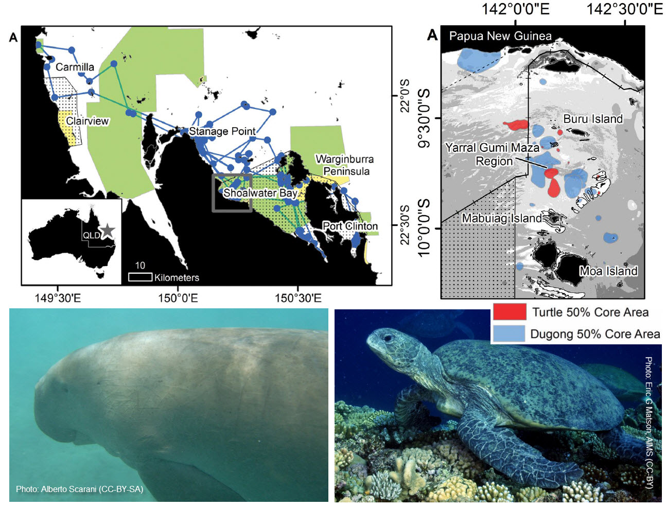
This dataset consists of the home ranges and satellite tracks taken from eleven dugongs and ten green turtles. Methods: Fast-acquisition satellite telemetry was used to track eleven dugongs and ten green turtles at two geographically distinct foraging locations in Queensland, Australia to evaluate the inter- and intra-species spatial relationships and assess the efficacy of existing protection zones. Home-range analysis and bathymetric modeling were used to determine spatial use and compared with existing protection areas using GIS. Raw, unfiltered tracking data were collected using fast acquisition GPS satellite transmitters attached to six dugongs (three females and three males) and four adult female green sea turtles near Mabuiag Island, Torres Strait, Australia in July 2009 and September 2010, and five dugongs (four females and one male) and six female green sea turtles (five adults and one prepubescent) in Shoalwater Bay, Australia in June/July 2012. The dugongs were captured using the dermal hold fast technique in Torres Strait and the standard rodeo technique in Shoalwater Bay. At both locations, the dugongs were fitted with Telonics Gen 4 GPS/ARGOS marine units attached to a 3 m tether linked to a padded tailstock harness. The green turtles were captured using the standard rodeo technique, brought to Mabuiag Island (Torres Strait) or MacDonald Point (Shoalwater Bay), and fitted with one of four types of satellite transmitters (Sirtrack F4G 291A, Wildlife Computers SPLASH10 BF-273A and Splash10 BF-273C, or SMRU SRDL 9000x). Each transmitter was attached to the carapace using the methods described in Shimada et al. (2012). Each turtle was released from shore the day after capture. Dugong units were programmed to collect a GPS position hourly; turtle units every 30 minutes. All units were programmed with a five minute repeat in case a signal was not received when the animal surfaced. Home-ranges were calculated for each animal using data from the entire period in which they were tracked and were calculated using fixed kernel density estimation with bandwidths selected by likelihood cross-validation (CVh). Kernel densities and bandwidths were calculated using the Geospatial Modelling Environment (GME), an extension to ArcGIS, with a resolution of 50 m. For a more detailed description of the methods see Gredzens(2014). Format: This dataset consists of shapefiles for the satellite tracks (lines and points) for the 21 animals as well as shapefiles for the calculated home ranges. References: Gredzens C, Marsh H, Fuentes MMPB, Limpus CJ, Shimada T, et al. (2014) Satellite Tracking of Sympatric Marine Megafauna Can Inform the Biological Basis for Species Co-Management. PLoS ONE 9(6): e98944. doi:10.1371/journal.pone.0098944 Data Location: This dataset is filed in the eAtlas enduring data repository at: data\NERP-TE\1.2_GBR-Turtles-dugong-monitoing
-
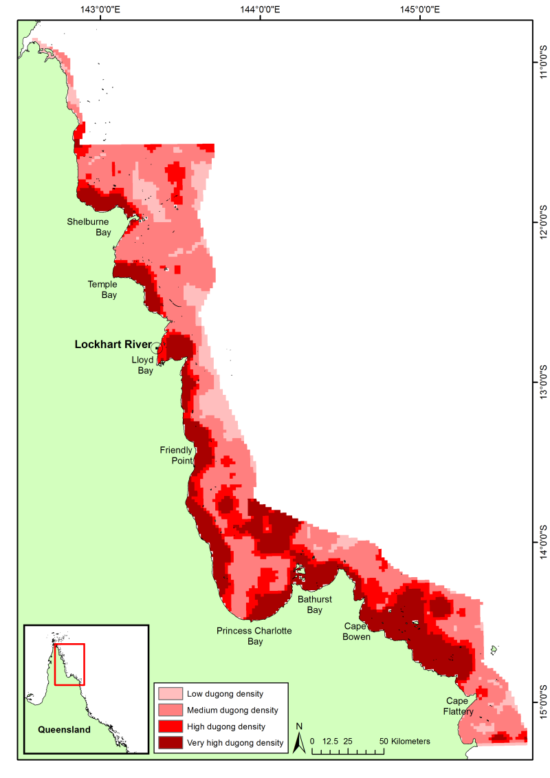
This dataset shows a raster spatial model of the distribution and relative density of dugongs (Dugong dugong) in the northern Great Barrier Reef region based on an aggregate of 24 years (1990 - 2013) of systematic aerial surveys. Methods: Aerial surveys were conducted using the strip transect method described by Marsh and Sinclair (1989). The survey region was divided into blocks containing systematic transects of varying length, which were typically perpendicular to the coast across the depth gradient. Tandem teams with two observers on each side of the aircraft independently recorded sightings of dugongs, including information on group size and calf numbers. Transects were 200 m wide at the water’s surface on either side of the aircraft. The spatial data from all the aerial surveys in the region (1990, 1995, 2000, 2006, and 2013) were corrected for differences in sampling intensity and area sampled between surveys. For details on sampling intensities and areas, please refer to the reports and publications for each individual survey (list below). The corrected data were then interpolated using universal kriging over the spatial extent of the aerial surveys. Planning units were 2km * 2km and were classified as low (1), medium (2), high (3) and very high (4) dugong density on the basis of the relative density of dugongs estimated from the model and a frequency analysis. Low density areas: 0 dugongs per square km; medium density areas 0.0015 - 0.25 dugongs per square km; high density areas 0.25 - 0.5 dugongs per square km; very high density areas > 0.5 dugongs per square km. Limitations: The modelled abundance and distribution show the relative density of dugongs (areas where there are more or less animals) and NOT the absolute dugong density as corrections for perception bias (animals that are available to, but missed by, observers) and availability bias (animals that are unavailable to observers because of water turbidity) can only be applied at the spatial scale of entire surveys (thousands of square kilometres), making them inappropriate for the spatial scale for this dataset. Nonetheless, the relative densities among regions should be approximately comparable (H. Marsh, personal communication). Format: The spatial model is 2481x3509 pixels with a spatial reference of WGS84 UTM Zone 54S. The original dataset is stored in ESRI GRID format (60 KB), which was converted to a GeoTiff for use in the eAtlas (134 kB). Both datasets are available under a creative commons attribution license. References: Publications for aerial surveys in the northern Great Barrier Reef: Marsh, H. & Corkeron, P. (1996). The status of the dugong in the northern Great Barrier Reef. Report to Great Barrier Reef Marine Park Authority, Townsville. Marsh, H. & Lawler, I. R. (2002). Dugong distribution and abundance in the Northern Great Barrier Reef Marine Park: November 2000. GBRMPA Research Publication 77. Townsville, Australia: Great Barrier Reef Marine Park Authority. Marsh, H.D., Hodgson, A., Lawler, I., Grech, A., & Delean, S. (2007) Condition, status, and trends and projected futures of the dugong in the Northern Great Barrier Reef and Torres Strait; including identification and evaluation of the key threats and evaluation of available management options to improve its status. Marine and Tropical Sciences Research Facility Reports Series. Reef and Rainforest Research Centre Limited, Cairns (77pp.). Data Location: This dataset is filed in the eAtlas enduring data repository at: data\NERP-TE\1.2_GBR-Turtles-dugong-monitoing
-
This project will monitor and study dugongs, dolphins and turtles along the coast of the GBRWHA with the following key tasks: 1. Determine the distribution and status of inshore dolphins in the northern Great Barrier Reef World Heritage Area (GBRWHA) by identifying likely important habitats based on collaboration with Tradition Owners and published information, then conduct line transect surveys (along with biopsy samples) in the Cardwell area (Girringun) and Bathurst Bay (far northern GBR). 2. Perform aerial surveys of Dugongs from the region from the southern boundary of the Great Barrier Reef World Heritage Area (GBRWHA) to Cooktown (2011/2012) and from Cooktown north in late 2013. 3. Perform at least two field trips per year between 2011 and 2014 to collect samples of skin (turtle and dugong), feces (dugong) and marine flora (seagrass, algae and mangrove species) to examine foraging dynamics and ecosystem role of green turtles and dugongs in algal and seagrass based ecosystems of the GBRWHA (coastal zone from Bowen to Cardwell). 4. The project will also work with Traditional Owners to improve conservation of these species of conservation concern and high cultural value.